A growing population demands more land for houses, schools, stores and roads. As Central Pennsylvania communities grow, so does the pressure to develop farmland to meet those needs.
But how we grow matters. Simply put: the more efficient we can be about using land, the better.
Sprawling, suburban development? Big lot sizes for new houses? Or, compact development and more walk-able, traditional neighborhoods?
These decisions make a big difference.
One important way you can help preserve farmland in your community is to engage with the land-use planning and zoning process.
Read on for more details.
How We Grow Matters
Centre County’s population reached 157,795 people as of July 1, 2023, according to the U.S. Census.
Watch how your community is growing. Are your township’s local zoning and land use policies helping to protect farmland? If not, you can engage local officials and advocate for policies and zoning to help protect farmland.
To protect farmland, planners both with Centre County and the Centre Region Council of Governments have identified promoting compact, efficient development and limiting “sprawl” and “leapfrog development” as priorities in land use policy.
Encroaching suburbanization is the greatest challenge to the preservation of farmland, according to the January 2020 Agricultural Comprehensive Plan, available from the agriculture page of the Planning & Community Development office of Centre County.
Limit Urban Sprawl
“With urban sprawl comes the fact that people are consuming more land, even when population and density remains steady,” the document explains.
Watch for these signs of urban sprawl:
- Large-lot residential development with low resident densities.
- Strip malls, big box stores and retail stores that are “decentralized” from a traditional downtown.
- Few mixed-use development areas
- Transportation limited to automobile access, with people highly dependent on personal vehicles.
Sprawl occurs more frequently in rural
~ 2020 Agricultural Comprehensive Plan
localities without land use controls and
zoning ordinances.
Limit Leapfrog Development
This term refers to developments located beyond existing beyond existing infrastructure like public water, public sewer and roads. Agricultural land is often targeted for this inefficient land practice because most farmland is located away from prime real estate, and available at a lower cost, offsetting the cost of providing this infrastructure, according to the Centre County 2020 Agricultural Comprehensive Plan.
“Leapfrog development” skips throughout the landscape, like pockets of urbanization.
Protect the Regional Growth Boundary in the Centre Region
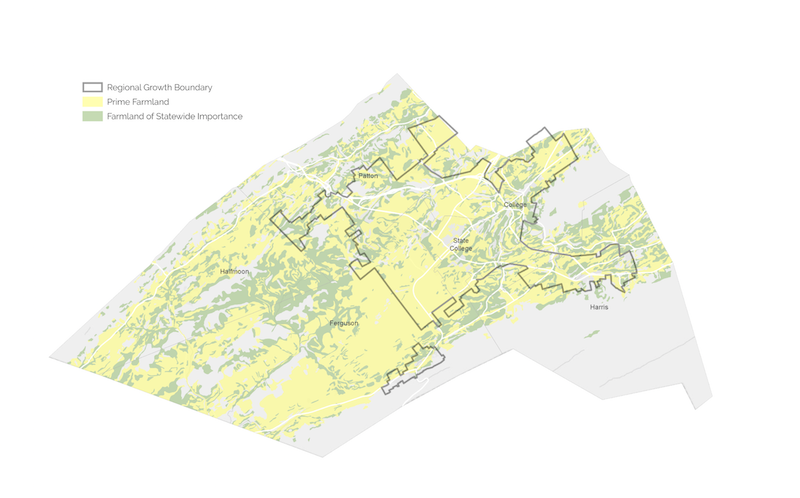
A critical tool to help discourage development of farmland in the Centre Region is the Regional Growth Boundary.
Established in 2000, the Regional Growth Boundary is a growth management strategy to steer growth to areas already served by infrastructure such as sewer services. The boundary has been expanded only once in 23 years.
“While the RGB can be expanded to accommodate future development needs, this can create conflicts with the Region’s goals to promote a compact development pattern, protect natural resources, and preserve the rural, agricultural hinterland that surrounds the existing RGB,” states the October 2020 Centre Region Land Consumption Study.
National Study & Forecasting Tool for Local Growth
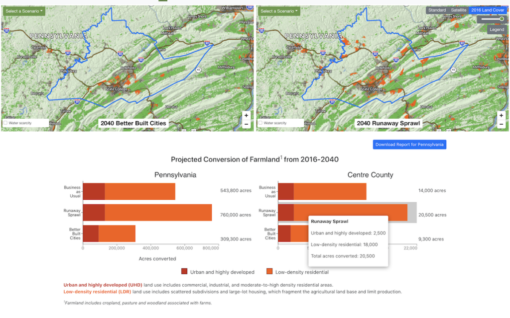
On a national level, the American Farmland Trust warns that whether growth is efficient and well-planned or becomes runaway sprawl will make the difference in the next few decades of whether the United States loses or saves millions of acres of farmland.
American Farmland Trust conducted geospatial analysis, modeling three development scenarios from 2016 until 2040 and how each would affect farmland throughout the United States.
Its report of results, Farms Under Threat 2040: Choosing an Abundant Future found:
- In Business as Usual, 18.4 million acres will be converted, an area nearly the size of South Carolina.
- In Runaway Sprawl, the toll could mount to 24.4 million acres—over 1 million acres paved over or compromised every year.
- But in Better Built Cities, policymakers and planners can slash conversion by up to 55% and save up to 13.5 million acres.
For Pennsylvania, an interactive map tool shows how the scenarios would play out at the county level.